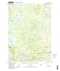
1951 Map of Kenai C-3
USGS Topo · Published 1981About this map
The Kenai River winds through this landscape on the Kenai Peninsula, marking a period of significant transition as the Swanson River Oil Field and various oil wells began to define the local economy. In the south, the settlements of Soldotna and Sterling are connected by the Sterling Highway, showing the early footprint of these communities before their modern expansion. Much of the northern terrain is preserved within the Kenai National Moose Range, a dense network of naming-rich water bodies including Whisper Lake, Scout Lake, and Doroshin Lake. The map reveals the infrastructure of early resource extraction and settlement, from the Robinson Loop Road to numerous landing strips and gravel pits. This survey captures the peninsula as it balanced wilderness conservation with the burgeoning petroleum industry and the growth of roadside communities along the highway corridor.
Find a feature on this map
80 named features on this map. Tap any name to fly to it.
Don’t see what you’re looking for? This feature index may not catch every label — zoom into the map to look around manually.
Map Details
Editions of this 1951 Kenai C-3 Map
4 editions found

Other maps of this area

1944 · Kenai
USGS Topo · 1:250,000

1950 · Kenai
USGS Topo · 1:250,000

1950 · Kenai C-3
USGS Topo · 1:63,360

1950 · Kenai B-3
USGS Topo · 1:63,360

1950 · Kenai D-4
USGS Topo · 1:63,360

1951 · Kenai D-3
USGS Topo · 1:63,360

1951 · Kenai B-2
USGS Topo · 1:63,360

1951 · Kenai C-2
USGS Topo · 1:63,360

1951 · Kenai D-2
USGS Topo · 1:63,360

1951 · Kenai C-4
USGS Topo · 1:63,360