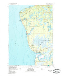
1951 Map of Kenai C-4
USGS Topo · Published 1986About this map
The Kenai River meets the Cook Inlet in this mid-century survey of the Kenai Peninsula’s western coast. The settlement of Kenai serves as the focal point, showing early infrastructure including the Kenai Airport and a Radio Range Station near the river mouth. The map documents the industrial and logistical development of the era, from the Wildwood Station Storage Tanks to the maritime activity at Nikiski Wharf. Further north, the landscape is defined by the East Foreland and the Lighthouse Reserve, while the eastern portion of the sheet transitions into the protected wilderness of the Kenai National Moose Range.
Find a feature on this map
46 named features on this map. Tap any name to fly to it.
Don’t see what you’re looking for? This feature index may not catch every label — zoom into the map to look around manually.
Map Details
Editions of this 1951 Kenai C-4 Map
3 editions found
Other maps of this area

1944 · Kenai
USGS Topo · 1:250,000

1950 · Kenai
USGS Topo · 1:250,000

1950 · Kenai C-3
USGS Topo · 1:63,360

1950 · Kenai B-3
USGS Topo · 1:63,360

1950 · Kenai D-4
USGS Topo · 1:63,360

1951 · Kenai D-3
USGS Topo · 1:63,360

1951 · Kenai C-4
USGS Topo · 1:63,360

1951 · Kenai C-3
USGS Topo · 1:63,360

1951 · Kenai B-4
USGS Topo · 1:63,360

1952 · Kenai D-3
USGS Topo · 1:63,360