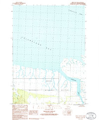
1986 Map of Kenai D-1 NE
USGS Topo · Published 1986About this map
Kenai National Wildlife Refuge dominates the landscape of this 1986 survey, illustrating a coastal wilderness defined by the dynamic relationship between the land and the sea. The map documents the shifting shoreline where the Chickaloon River meets the expansive Chickaloon Bay, a region characterized by intricate tidal flats and marshy lowlands. To the north, the waters of Turnagain Arm reach into the peninsula, while inland drainage is marked by smaller waterways like Pincher Creek. The notation that the boundary follows the shoreline emphasizes the fluid nature of this environment, where land and water are constantly renegotiated by the tides. This provisional study, based on 1970s aerial photography, captures the natural state of the northern Kenai Peninsula before modern development or major ecological shifts altered its primary watercourses.
Find a feature on this map
6 named features on this map. Tap any name to fly to it.
Don’t see what you’re looking for? This feature index may not catch every label — zoom into the map to look around manually.
Map Details
Editions of this 1986 Kenai D-1 NE Map
This is the sole edition of this map. No revisions or reprints were ever made.
Other maps of this area

1944 · Kenai
USGS Topo · 1:250,000

1949 · Tyonek
USGS Topo · 1:250,000

1950 · Kenai
USGS Topo · 1:250,000

1951 · Seward
USGS Topo · 1:250,000

1951 · Anchorage
USGS Topo · 1:250,000

1951 · Tyonek
USGS Topo · 1:250,000

1951 · Kenai D-1
USGS Topo · 1:63,360

1951 · Seward D-8
USGS Topo · 1:63,360

1951 · Tyonek A-1
USGS Topo · 1:63,360

1952 · Tyonek A-1
USGS Topo · 1:63,360