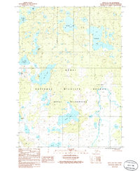
1986 Map of Kenai D-1 SW
USGS Topo · Published 1986About this map
The Kenai National Wildlife Refuge dominates this mid-1980s topographic study, revealing a complex landscape of glacial kettle lakes and muskeg in the Kenai Wilderness. This portion of the Kenai Peninsula is defined by its intricate hydrological network, where larger bodies of water like Barabara Lake, Sportfish Lake, and King Lake are separated by low ridges and thousands of smaller, unnamed ponds. The Chickaloon River meanders through the eastern section of the quadrangle, serving as a primary drainage for the area. A single Cabin is marked near the western boundary, signifying the sparse human footprint in this protected region. The map captures the territory as it was documented from 1975 aerial photography and 1986 field checks, illustrating the natural state of the peninsula before more contemporary shifts in local climate and vegetation patterns.
Find a feature on this map
16 named features on this map. Tap any name to fly to it.
Don’t see what you’re looking for? This feature index may not catch every label — zoom into the map to look around manually.
Map Details
Editions of this 1986 Kenai D-1 SW Map
This is the sole edition of this map. No revisions or reprints were ever made.
Other maps of this area

1944 · Kenai
USGS Topo · 1:250,000

1950 · Kenai
USGS Topo · 1:250,000

1951 · Kenai C-1
USGS Topo · 1:63,360

1951 · Kenai C-2
USGS Topo · 1:63,360

1951 · Kenai D-1
USGS Topo · 1:63,360

1951 · Kenai D-2
USGS Topo · 1:63,360

1952 · Kenai D-2
USGS Topo · 1:63,360

1952 · Kenai C-1
USGS Topo · 1:63,360

1952 · Kenai C-2
USGS Topo · 1:63,360
1952 · Kenai D-1
USGS Topo · 1:63,360