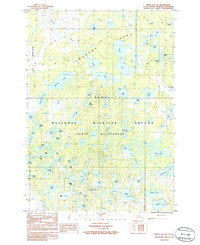
1986 Map of Kenai D-2 SE
USGS Topo · Published 1986About this map
Kenai National Wildlife Refuge dominates this mid-1980s landscape, illustrating a complex sub-arctic mosaic of countless kettle lakes and meandering waterways. The Swanson River snakes through the northern portion of the quadrangle, serving as a primary drainage for the surrounding Kenai Wilderness. This period represents a time of preserved environmental study, where the naming of even small water bodies like Red Squirrel Lake, Nuthatch Lake, and Twig Lake indicates a high degree of biological and geographic cataloging within the refuge boundaries. The density of named features like Pepper Lake and Lake Swanson reveals the intricate hydrological network of the Kenai Peninsula before modern development patterns could alter these natural catchments. For those studying the history of Alaskan conservation, the map provides an exact record of the Wilderness Boundary and the established trail systems near Campers Lake and Woods Lake.
Find a feature on this map
59 named features on this map. Tap any name to fly to it.
Don’t see what you’re looking for? This feature index may not catch every label — zoom into the map to look around manually.
Map Details
Editions of this 1986 Kenai D-2 SE Map
This is the sole edition of this map. No revisions or reprints were ever made.
Other maps of this area

1944 · Kenai
USGS Topo · 1:250,000

1950 · Kenai
USGS Topo · 1:250,000

1951 · Kenai C-1
USGS Topo · 1:63,360

1951 · Kenai C-2
USGS Topo · 1:63,360

1951 · Kenai D-1
USGS Topo · 1:63,360

1951 · Kenai D-2
USGS Topo · 1:63,360

1952 · Kenai D-2
USGS Topo · 1:63,360

1952 · Kenai C-1
USGS Topo · 1:63,360

1952 · Kenai C-2
USGS Topo · 1:63,360
1952 · Kenai D-1
USGS Topo · 1:63,360