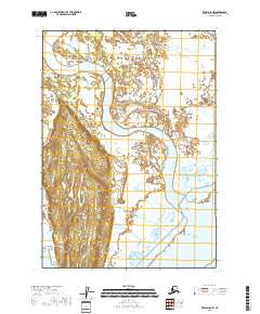
2018 Map of Kenai D-5 NW
USGS Topo · Published 2018About this map
The McArthur River dominates this coastal landscape on the Kenai Peninsula, where it meanders through the expansive McArthur Flats. This area is defined by a complex network of waterways, including the Chakachatna River and numerous tidal channels like Cottonwood Slough and Seal Slough. These features reveal a dynamic environment where freshwater rivers meet the tidal influence of the Cook Inlet region.
Find a feature on this map
13 named features on this map. Tap any name to fly to it.
Don’t see what you’re looking for? This feature index may not catch every label — zoom into the map to look around manually.
Map Details
Editions of this 2018 Kenai D-5 NW Map
This is the sole edition of this map. No revisions or reprints were ever made.
Other maps of this area

1944 · Kenai
USGS Topo · 1:250,000

1949 · Tyonek
USGS Topo · 1:250,000

1950 · Kenai
USGS Topo · 1:250,000

1951 · Tyonek
USGS Topo · 1:250,000

1958 · Tyonek A-6
USGS Topo · 1:63,360

1958 · Tyonek A-5
USGS Topo · 1:63,360

1958 · Kenai D-5
USGS Topo · 1:63,360

1958 · Kenai D-6
USGS Topo · 1:63,360

1958 · Tyonek
USGS Topo · 1:250,000

1958 · Kenai
USGS Topo · 1:250,000