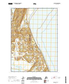
2018 Map of Kenai D-5 SW
USGS Topo · Published 2018About this map
West Foreland and its surrounding wetlands define this landscape on the western shore of the Pacific Ocean, where the Kustatan River meets the coast. The map illustrates a specialized industrial environment on the Kenai Peninsula, marked by the presence of the Trading Bay Production Airport. This coastal interface is characterized by a low-lying, marshy terrain that transitions from the inland Bunitlana Lake toward the tidal flats. The infrastructure suggests a landscape focused on resource production and logistical access rather than traditional residential development, typical of this remote stretch of the Alaska coast during the early 21st century.
Find a feature on this map
10 named features on this map. Tap any name to fly to it.
Don’t see what you’re looking for? This feature index may not catch every label — zoom into the map to look around manually.
Map Details
Editions of this 2018 Kenai D-5 SW Map
This is the sole edition of this map. No revisions or reprints were ever made.
Other maps of this area

1944 · Kenai
USGS Topo · 1:250,000

1950 · Kenai
USGS Topo · 1:250,000

1958 · Kenai C-5
USGS Topo · 1:63,360

1958 · Kenai D-5
USGS Topo · 1:63,360

1958 · Kenai C-6
USGS Topo · 1:63,360

1958 · Kenai D-6
USGS Topo · 1:63,360

1958 · Kenai
USGS Topo · 1:250,000
2018 · Kenai D-5 NW
USGS Topo · 1:25,000
2018 · Kenai C-5 NW
USGS Topo · 1:25,000
2018 · Kenai D-6 NE
USGS Topo · 1:25,000