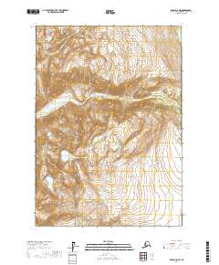
2017 Map of Kenai D-6 NW
USGS Topo · Published 2017About this map
Lake Clark National Park encompasses the southern portion of this high-elevation terrain, where the landscape is defined by steep ridges and glacial valleys. The northern sections are dominated by unnamed peaks and deep drainages, with Blacksand Creek (also labeled Blacksand Cr) cutting westward through the central mountains. This 2017 survey reflects a wilderness area devoid of modern infrastructure, roads, or settlements, focusing instead on the complex topography and natural hydrology of the Kenai Peninsula. The map provides a detailed view of the natural drainage patterns that feed into the larger Bristol Bay watershed, showing how small mountain streams coalesce into significant features like Blacksand Creek amidst a landscape shaped by tectonic and glacial history.
Find a feature on this map
9 named features on this map. Tap any name to fly to it.
Don’t see what you’re looking for? This feature index may not catch every label — zoom into the map to look around manually.
Map Details
Editions of this 2017 Kenai D-6 NW Map
This is the sole edition of this map. No revisions or reprints were ever made.
Other maps of this area

1944 · Kenai
USGS Topo · 1:250,000

1949 · Tyonek
USGS Topo · 1:250,000

1950 · Kenai
USGS Topo · 1:250,000

1951 · Tyonek
USGS Topo · 1:250,000

1958 · Tyonek A-6
USGS Topo · 1:63,360

1958 · Kenai D-6
USGS Topo · 1:63,360

1958 · Kenai D-7
USGS Topo · 1:63,360

1958 · Tyonek
USGS Topo · 1:250,000
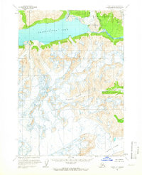
1958 · Tyonek A-7
USGS Topo · 1:63,360

1958 · Kenai
USGS Topo · 1:250,000