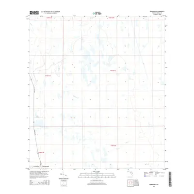
2015 Map of Kenansville
USGS Topo · Published 2015About this map
Kenansville anchors the southwest corner of this Osceola County landscape, where the flatwoods are defined by an intricate network of slow-moving drainages and shallow wetlands. The hydrology of the region is characterized by named water bodies such as Billy Lake and Clayhole Pond, which sit amidst a series of meandering branches including Tracy Br, Yoke Br, and the elongated Hammock Br. This terrain reflects the typical interior Florida drainage patterns where subtle elevation changes dictate the flow of systems like Bull Cr and Tenmile Cr. Local transportation is concentrated along N Kenansville Rd and S Canoe Creek Rd, connecting the small settlement to the surrounding ranching and conservation lands. The map captures the interface between these rural road corridors and the natural creek systems like Wolf Cr and Tyson Cr.
Find a feature on this map
23 named features on this map. Tap any name to fly to it.
Don’t see what you’re looking for? This feature index may not catch every label — zoom into the map to look around manually.
Map Details
Editions of this 2015 Kenansville Map
This is the sole edition of this map. No revisions or reprints were ever made.
Other maps of this area

1953 · Lake Marian SE
USGS Topo · 1:24,000

1953 · Holopaw SE
USGS Topo · 1:24,000

1953 · Kenansville SW
USGS Topo · 1:24,000

1953 · Deer Park SE
USGS Topo · 1:24,000

1953 · Kenansville
USGS Topo · 1:24,000

1953 · Kenansville NE
USGS Topo · 1:24,000

1953 · Kenansville SE
USGS Topo · 1:24,000

1953 · Deer Park
USGS Topo · 1:24,000

1953 · Lake Marian NE
USGS Topo · 1:24,000

1955 · Orlando
USGS Topo · 1:250,000