
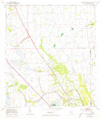
1953 Map of Kenansville SW
USGS Topo · Published 1954About this map
Kenansville and the settlement of Lokosee anchor this mid-century survey of the Florida interior, where the landscape is defined by extensive wetlands and intentional drainage modifications. The presence of numerous Spoil Bank features along the watercourses indicates a period of significant land management and canal construction, likely to support the burgeoning agricultural interests of the early 1950s. This survey, compiled in part by the U.S. Corps of Engineers, shows a territory transitioning from its natural state toward more controlled land use. Evidence of former industrial activity is visible in the Old Railroad Grade, which traces through the landscape as a relic of previous timber or transit networks. Natural drainage continues through Sixmile Creek and various unnamed Creek systems, while the boundary between Osceola Co and Indian River Co highlights the administrative divisions of this marshy terrain.
Find a feature on this map
7 named features on this map. Tap any name to fly to it.
Don’t see what you’re looking for? This feature index may not catch every label — zoom into the map to look around manually.
Map Details
Editions of this 1953 Kenansville SW Map
2 editions found
Other maps of this area

1953 · Fort Kissimmee NE
USGS Topo · 1:24,000

1953 · Lake Marian SE
USGS Topo · 1:24,000

1953 · Fort Drum NW
USGS Topo · 1:24,000

1953 · Kenansville
USGS Topo · 1:24,000

1953 · Fort Drum NE
USGS Topo · 1:24,000

1953 · Kenansville NE
USGS Topo · 1:24,000

1953 · Kenansville SE
USGS Topo · 1:24,000

1953 · Lake Marian NE
USGS Topo · 1:24,000

1956 · Fort Pierce
USGS Topo · 1:250,000

1958 · Fort Pierce
USGS Topo · 1:250,000