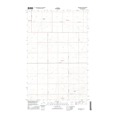
2017 Map of Kenilworth NE
USGS Topo · Published 2017About this map
Twelvemile Coulee carves through the northern reaches of this landscape in Chouteau County, marking a terrain defined by subtle drainage patterns and a rigorous section-line road grid. This part of Montana reflects a deeply organized agricultural footprint, where the vast open spaces are partitioned by thoroughfares like Kenilworth Rd and N Gardiner Rd. The southeastern corner is notably more textured, as the elevation drops toward Dry Fork Coulee, a landform that dictates the winding path of Homesteader Ln. These local names, including Blankenbaker Rd and Winchester Rd, often reflect the pioneering families who established the homesteads and ranches that comprise this rural district. The map serves as a precise record of the contemporary infrastructure supporting the grain and cattle economies of the High Plains.
Find a feature on this map
16 named features on this map. Tap any name to fly to it.
Don’t see what you’re looking for? This feature index may not catch every label — zoom into the map to look around manually.
Map Details
Editions of this 2017 Kenilworth NE Map
This is the sole edition of this map. No revisions or reprints were ever made.
Other maps of this area

1904 · Boxelder
USGS Topo · 1:62,500

1906 · Lonesome
USGS Topo · 1:62,500

1906 · Boxelder
USGS Topo · 1:62,500

1919 · Big Sandy
USGS Topo · 1:125,000

1953 · Boggs Island
USGS Topo · 1:24,000

1953 · Verona
USGS Topo · 1:24,000

1954 · Shelby
USGS Topo · 1:250,000

1958 · Shelby
USGS Topo · 1:250,000

1969 · Fourteenmile Coulee SW
USGS Topo · 1:24,000
1969 · Lonesome Lake
USGS Topo · 1:24,000