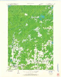
1941 Map of Kennan
USGS Topo · Published 1966About this map
The Minneapolis St Paul and Sault Ste Marie railroad defines the southern industrial corridor of this landscape, connecting the rural centers of Hawkins, Kennan, and Catawba. This 1941 field examination reveals a highly organized network of local school districts, including Old Mill Sch, Martins Hill Sch, and Four Corners Sch, which served the farming and timber families of Price and Rusk Counties. The northern half of the map is dominated by the Flambeau River and the South Fork Flambeau River, where logging infrastructure like Kraft Camp and Camp Merril supported the regional timber economy.
Find a feature on this map
55 named features on this map. Tap any name to fly to it.
Don’t see what you’re looking for? This feature index may not catch every label — zoom into the map to look around manually.
Map Details
Editions of this 1941 Kennan Map
2 editions found
Other maps of this area

1941 · Park Falls
USGS Topo · 1:48,000

1941 · Kennan
USGS Topo · 1:48,000

1941 · Kennedy
USGS Topo · 1:48,000

1941 · Phillips
USGS Topo · 1:48,000

1943 · Park Falls
USGS Topo · 1:48,000

1943 · Philliips
USGS Topo · 1:48,000

1944 · Ogema
USGS Topo · 1:48,000

1944 · Draper
USGS Topo · 1:48,000

1945 · Kennedy
USGS Topo · 1:48,000

1945 · Kennan
USGS Topo · 1:48,000