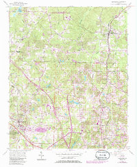
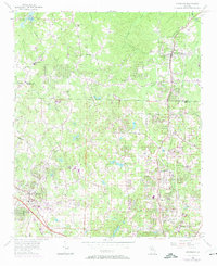
1956 Map of Kennesaw
USGS Topo · Published 1986About this map
Noonday Creek and its many tributaries carve through this north Georgia landscape, where the transition from rural agricultural districts to modern suburban development is clearly visible in the mid-1980s updates. The city of Kennesaw sits in the southwestern corner, anchored by the Seaboard Coast Line railroad and the nearby McCollum Airport. To the north, the terrain remains more wooded, protected in part by the Little River State Wildlife Management Area near Allatoona Lake. Local heritage is preserved in the numerous community centers that dot the grid, from the Oak Grove School and Blackwells School to historic congregations like Rose Creek Church and Shiloh Church. The map traces the early road network including Shallow Ford Road and Ebenezer Road, alongside older family-named landmarks like Posey and Blackwells.
Find a feature on this map
41 named features on this map. Tap any name to fly to it.
Don’t see what you’re looking for? This feature index may not catch every label — zoom into the map to look around manually.
Map Details
Editions of this 1956 Kennesaw Map
5 editions found
Other maps of this area

1888 · Atlanta
USGS Topo · 1:125,000

1890 · Suwanee
USGS Topo · 1:125,000

1890 · Cartersville
USGS Topo · 1:125,000

1890 · Atlanta
USGS Topo · 1:125,000

1891 · Marietta
USGS Topo · 1:125,000

1891 · Cartersville
USGS Topo · 1:125,000

1892 · Atlanta
USGS Topo · 1:125,000

1894 · Suwanee
USGS Topo · 1:125,000

1895 · Atlanta
USGS Topo · 1:125,000

1895 · Marietta
USGS Topo · 1:125,000