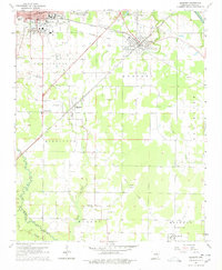
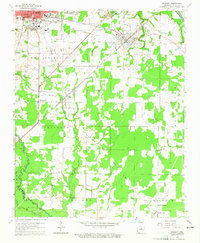
1964 Map of Kensett
USGS Topo · Published 1978About this map
Searcy and the campus of Harding College anchor the northwestern corner of this mid-1960s landscape, where the transition from municipal development to the agricultural bottomlands of White County is clearly defined. The area is shaped by a dense network of watercourses, including the Little Red River and Bayou Des Arc, which dictate the placement of early settlements and rural infrastructure. The Missouri Pacific railroad runs diagonally through Kensett and Higginson, serving as a primary transportation corridor alongside the Old Railroad Grade. This survey captures a moment when rural life centered around local landmarks such as Morrow Ch, the Training Sch, and numerous family burial grounds like Lessenberry Cem and Crow Cem, providing a detailed spatial record of the community before modern highway expansion and suburban infill altered the original township lines.
Find a feature on this map
40 named features on this map. Tap any name to fly to it.
Don’t see what you’re looking for? This feature index may not catch every label — zoom into the map to look around manually.
Map Details
Editions of this 1964 Kensett Map
3 editions found
Other maps of this area

1932 · Kensett
USGS Topo · 1:62,500

1935 · Kensett
USGS Topo · 1:62,500

1935 · Bald Knob
USGS Topo · 1:62,500

1953 · Memphis
USGS Topo · 1:250,000

1956 · Memphis
USGS Topo · 1:250,000

1962 · Letona
USGS Topo · 1:24,000

1963 · Garner
USGS Topo · 1:24,000
1963 · Mc Rae
USGS Topo · 1:24,000
1964 · Walker
USGS Topo · 1:24,000
1964 · Kensett
USGS Topo · 1:24,000