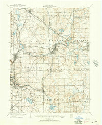
1906 Map of Kent
USGS Topo · Published 1950About this map
The Cuyahoga River anchors a landscape of dense industrial and transit infrastructure at the start of the twentieth century, where the growing city of Kent serves as a critical junction for the Erie RR and the Wheeling and Lake Erie RR. The surrounding Portage and Summit County townships are characterized by a transition from agricultural crossroads like Brimfield Station and Streetsboro to burgeoning industrial centers. In the southwest, the outskirts of Akron and East Akron show the early expansion of the rubber capital, while the Little Cuyahoga River winds through settlements like Mogadore and Brittain. Numerous glacial lakes, including Springfield Lake, Silver Lake, and Brady Lake, dot the terrain, many already developed as recreation spots accessible by electric rail lines such as the Akron Bedford and Cleveland Electric RR.
Find a feature on this map
76 named features on this map. Tap any name to fly to it.
Don’t see what you’re looking for? This feature index may not catch every label — zoom into the map to look around manually.
Map Details
Editions of this 1906 Kent Map
2 editions found
Other maps of this area

1901 · Massillon
USGS Topo · 1:62,500

1901 · Canton
USGS Topo · 1:62,500

1903 · Massillon
USGS Topo · 1:62,500

1903 · Cleveland
USGS Topo · 1:62,500

1903 · Canton
USGS Topo · 1:62,500

1903 · Akron
USGS Topo · 1:62,500

1905 · Akron
USGS Topo · 1:62,500

1905 · Garrettsville
USGS Topo · 1:62,500

1906 · Kent
USGS Topo · 1:62,500

1906 · Chagrin Falls
USGS Topo · 1:62,500