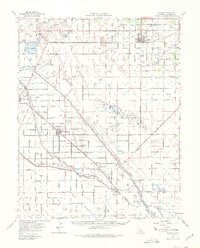
1963 Map of Kerman
USGS Topo · Published 1980About this map
Agricultural development and water management define this portion of the San Joaquin Valley, where the Southern Pacific railroad connects established settlements like Kerman and San Joaquin. The landscape is dominated by a grid of rural avenues and significant water infrastructure, including the James Bypass, Fresno Slough, and the Main Canal. These features highlight the region's reliance on large-scale irrigation for its productivity. In addition to the town centers, smaller nodes such as Tranquillity, Jamesan, and Helm appear alongside specialized landmarks like the Radio Tower (KMJ). Local history is reflected in the presence of a Cem and family-named locations like Traction Ranch. The map also reveals the extraction economy of the era, with clusters of Oil Wells and Gas Wells appearing in the southern reaches of the quadrangle.
Find a feature on this map
53 named features on this map. Tap any name to fly to it.
Don’t see what you’re looking for? This feature index may not catch every label — zoom into the map to look around manually.
Map Details
Editions of this 1963 Kerman Map
2 editions found
Other maps of this area

1912 · Coalinga
USGS Topo · 1:125,000

1921 · Mendota
USGS Topo · 1:31,680

1923 · Kearney Park
USGS Topo · 1:31,680

1923 · Herndon
USGS Topo · 1:31,680

1923 · Englebrecht Ranch
USGS Topo · 1:31,680

1923 · Biola
USGS Topo · 1:31,680

1924 · Jamesan
USGS Topo · 1:31,680

1924 · Tranquillity
USGS Topo · 1:31,680

1924 · Gravelly Ford
USGS Topo · 1:31,680

1924 · Mendota
USGS Topo · 1:31,680