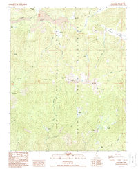
1988 Map of Kern Peak
USGS Topo · Published 1988About this map
Kern Peak and the high Sierra Nevada landscape dominate this high-altitude survey of Tulare County. The area is defined by the protected lands of the Inyo National Forest and the Golden Trout Wilderness, where complex drainage patterns are formed by Golden Trout Creek and the South Fork Kern River. A distinct volcanic character is evident in the northern portion of the map, specifically around the Malpais and Volcano Meadow. This 1980s data records the wilderness infrastructure of the era, including the isolated Tunnel FS Station and numerous alpine crossings such as Right Stringer Pass and Saddle Camp Pass. The presence of the Natural Bridge and geological landmarks like Three Rocks highlights a terrain largely shaped by natural forces rather than permanent settlement.
Find a feature on this map
39 named features on this map. Tap any name to fly to it.
Don’t see what you’re looking for? This feature index may not catch every label — zoom into the map to look around manually.
Map Details
Editions of this 1988 Kern Peak Map
2 editions found
Other maps of this area

1905 · Olancha
USGS Topo · 1:125,000

1907 · Olancha
USGS Topo · 1:125,000

1948 · Fresno
USGS Topo · 1:250,000

1955 · Fresno
USGS Topo · 1:250,000

1956 · Fresno
USGS Topo · 1:250,000

1956 · Hockett Peak
USGS Topo · 1:62,500
1956 · Monache Mtn
USGS Topo · 1:62,500

1956 · Olancha
USGS Topo · 1:62,500
1956 · Kern Peak
USGS Topo · 1:62,500

1958 · Fresno
USGS Topo · 1:250,000