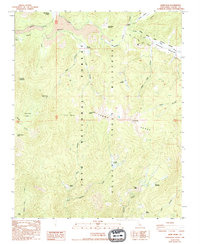
1988 Map of Kern Peak
USGS Topo · Published 1994About this map
Kern Peak serves as the focal point for this survey of the high Sierras, rising within the Toowah Range and overlooking a complex network of glacial meadows and alpine watercourses. The landscape is dominated by the hydrology of Golden Trout Creek and the South Fork Kern River, which meanders through Ramshaw Meadows along the eastern boundary. This high-altitude drainage system is punctuated by unique geological formations, including the Natural Bridge near Malpais and the volcanic character of Volcano Meadow.
Find a feature on this map
39 named features on this map. Tap any name to fly to it.
Don’t see what you’re looking for? This feature index may not catch every label — zoom into the map to look around manually.
Map Details
Editions of this 1988 Kern Peak Map
2 editions found
Other maps of this area

1905 · Olancha
USGS Topo · 1:125,000

1907 · Olancha
USGS Topo · 1:125,000

1948 · Fresno
USGS Topo · 1:250,000

1955 · Fresno
USGS Topo · 1:250,000

1956 · Fresno
USGS Topo · 1:250,000

1956 · Hockett Peak
USGS Topo · 1:62,500
1956 · Monache Mtn
USGS Topo · 1:62,500

1956 · Olancha
USGS Topo · 1:62,500
1956 · Kern Peak
USGS Topo · 1:62,500

1958 · Fresno
USGS Topo · 1:250,000