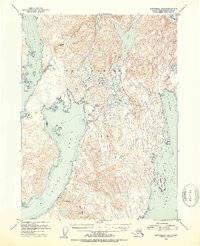
1952 Map of Ketchikan B-4
USGS Topo · Published 1954About this map
Revillagigedo Island presents a landscape defined by deep fjords and a dense network of freshwater lakes within the Tongass National Forest. This 1952 topographic study, compiled from earlier aerial photography and maritime charts, captures the intersection of industrial attempts and raw wilderness in Southeast Alaska. The presence of the Sealevel Mine (Aban'd) near the shoreline of Thorne Arm points to the region's history of hard-rock mineral exploration. Water management and resource monitoring are evident at the Gaging Station located along Fish Creek. Steep topography, ranging from Painted Peak to the sharp ridges of Notch Mtn, funnels into massive waterways like Carroll Inlet and the Behm Canal, illustrating the isolation and water-dependent nature of early coastal activity in the Ketchikan area.
Find a feature on this map
45 named features on this map. Tap any name to fly to it.
Don’t see what you’re looking for? This feature index may not catch every label — zoom into the map to look around manually.
Map Details
Editions of this 1952 Ketchikan B-4 Map
2 editions found
Other maps of this area

1948 · Ketchikan C-5
USGS Topo · 1:63,360

1949 · Ketchikan B-4
USGS Topo · 1:63,360

1952 · Ketchikan
USGS Topo · 1:250,000

1952 · Ketchikan B-4
USGS Topo · 1:63,360

1952 · Ketchikan C-4
USGS Topo · 1:63,360

1953 · Ketchikan C-5
USGS Topo · 1:63,360

1954 · Ketchikan B-5
USGS Topo · 1:63,360

1955 · Ketchikan C-3
USGS Topo · 1:63,360

1955 · Ketchikan A-4
USGS Topo · 1:63,360

1955 · Ketchikan A-5
USGS Topo · 1:63,360