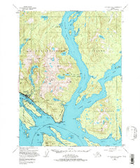
1955 Map of Ketchikan B-5
USGS Topo · Published 1978About this map
The port city of Ketchikan serves as the focal point of this coastal survey, situated along the Tongass Narrows where the sea meets the steep slopes of Deer Mtn. The maritime character of the area is evident in the Ketchikan Harbor, the Seaplane Base, and the U.S. Coast Guard Station. Industrial and recreational history is marked by the presence of the Beaver Falls Power House, a mountain Aqueduct, and the White River Boy Scout Camp located near the head of George Inlet.
Find a feature on this map
94 named features on this map. Tap any name to fly to it.
Don’t see what you’re looking for? This feature index may not catch every label — zoom into the map to look around manually.
Map Details
Editions of this 1955 Ketchikan B-5 Map
3 editions found

Other maps of this area

1948 · Ketchikan A-6
USGS Topo · 1:63,360

1948 · Ketchikan C-5
USGS Topo · 1:63,360

1949 · Ketchikan C-6
USGS Topo · 1:63,360

1949 · Ketchikan B-4
USGS Topo · 1:63,360

1952 · Ketchikan
USGS Topo · 1:250,000

1952 · Ketchikan B-4
USGS Topo · 1:63,360

1952 · Ketchikan C-4
USGS Topo · 1:63,360

1952 · Ketchikan C-6
USGS Topo · 1:63,360

1953 · Ketchikan C-5
USGS Topo · 1:63,360

1953 · Ketchikan B-6
USGS Topo · 1:63,360