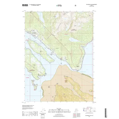
2017 Map of Ketchikan B-5 SW
USGS Topo · Published 2017About this map
Ketchikan and the neighboring community of Saxman occupy the narrow coastal shelf of Revillagigedo Island, where the steep ascent of the Deer Mountains begins almost immediately from the shoreline of the Tongass Narrows. This coastal corridor is defined by its deep-water access and the infrastructure supporting it, including South Tongass highway and various local roads like Killer Whale Avenue. The map shows a clear division between the developed port areas and the protected wilderness of the Tongass National Forest, which covers the majority of the interior peaks such as Achilles Mtn and Roy Jones Mtn.
Find a feature on this map
75 named features on this map. Tap any name to fly to it.
Don’t see what you’re looking for? This feature index may not catch every label — zoom into the map to look around manually.
Map Details
Editions of this 2017 Ketchikan B-5 SW Map
This is the sole edition of this map. No revisions or reprints were ever made.
Other maps of this area

1948 · Ketchikan A-6
USGS Topo · 1:63,360

1952 · Ketchikan
USGS Topo · 1:250,000

1953 · Ketchikan B-6
USGS Topo · 1:63,360

1954 · Ketchikan B-5
USGS Topo · 1:63,360

1954 · Ketchikan B-6
USGS Topo · 1:63,360

1955 · Ketchikan A-5
USGS Topo · 1:63,360

1955 · Ketchikan
USGS Topo · 1:250,000

1955 · Ketchikan B-5
USGS Topo · 1:63,360
1991 · Ketchikan B-5 SW
USGS Topo · 1:25,000
1991 · Ketchikan B-5 NW
USGS Topo · 1:25,000