
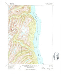
1955 Map of Ketchikan C-1
USGS Topo · Published 1960About this map
Portland Canal serves as the central focal point of this 1950s survey, marking the international maritime boundary between the British Columbia and United States. This portion of the Tongass National Forest is dominated by the steep elevations of the Halleck Range, which rises sharply from the eastern shoreline. The map documents a strictly coastal orientation, with numerous maritime landmarks used for navigation and boundary monitoring, including Verdure Pt, Miners Pt, and the small outcrop of Green Island.
Find a feature on this map
24 named features on this map. Tap any name to fly to it.
Don’t see what you’re looking for? This feature index may not catch every label — zoom into the map to look around manually.
Map Details
Editions of this 1955 Ketchikan C-1 Map
2 editions found
Other maps of this area

1952 · Ketchikan
USGS Topo · 1:250,000

1955 · Ketchikan D-2
USGS Topo · 1:63,360

1955 · Ketchikan C-2
USGS Topo · 1:63,360

1955 · Ketchikan B-2
USGS Topo · 1:63,360

1955 · Ketchikan B-1
USGS Topo · 1:63,360

1955 · Ketchikan D-1
USGS Topo · 1:63,360

1955 · Ketchikan
USGS Topo · 1:250,000

1996 · Ketchikan C-2
USGS Topo · 1:63,360
1996 · Ketchikan D-2
USGS Topo · 1:63,360
2018 · Ketchikan B-1 NE
USGS Topo · 1:25,000