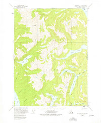
1955 Map of Ketchikan C-4
USGS Topo · Published 1976About this map
Revillagigedo Island reveals its complex network of glacially carved valleys and freshwater systems in this mid-century survey. The landscape is defined by deep maritime penetrations, such as the northern reaches of Carroll Inlet and the expansive Behm Canal to the northeast. Interior features suggest a wilderness utilized by hunters, researchers, or foresters, marked by isolated structures like Manzanita Camp Cabin and various Shelter Cabins near prominent water bodies.
Find a feature on this map
23 named features on this map. Tap any name to fly to it.
Don’t see what you’re looking for? This feature index may not catch every label — zoom into the map to look around manually.
Map Details
Editions of this 1955 Ketchikan C-4 Map
3 editions found

Other maps of this area

1948 · Ketchikan C-5
USGS Topo · 1:63,360

1949 · Ketchikan B-4
USGS Topo · 1:63,360

1952 · Ketchikan
USGS Topo · 1:250,000

1952 · Ketchikan B-4
USGS Topo · 1:63,360

1952 · Ketchikan C-4
USGS Topo · 1:63,360

1952 · Ketchikan D-5
USGS Topo · 1:63,360

1953 · Ketchikan C-5
USGS Topo · 1:63,360

1953 · Ketchikan D-5
USGS Topo · 1:63,360

1954 · Ketchikan B-5
USGS Topo · 1:63,360

1955 · Ketchikan C-3
USGS Topo · 1:63,360