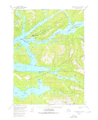
1952 Map of Ketchikan D-5
USGS Topo · Published 1976About this map
Bell Island Hot Springs serves as a distinct point of human activity within this 1952 topographic study of the Ketchikan Gateway Borough. Located on the northern shore of Bell Island, the site features a noted Seaplane Ramp, highlighting the region's reliance on air and water travel. The map captures the complex waterways of the Alexander Archipelago, where Behm Canal separates the mainland from the large masses of Revillagigedo Island and Hassler Island. This era of the Tongass National Forest is defined by a landscape of deep fjords and isolated lakes, such as Orchard Lake and Lake Shelokum. The intricate shoreline details at Neets Bay and Shrimp Bay offer a glimpse into the maritime geography before modern development shifted the character of these remote Alaskan inlets.
Find a feature on this map
44 named features on this map. Tap any name to fly to it.
Don’t see what you’re looking for? This feature index may not catch every label — zoom into the map to look around manually.
Map Details
Editions of this 1952 Ketchikan D-5 Map
Other maps of this area

1948 · Ketchikan C-5
USGS Topo · 1:63,360

1949 · Ketchikan C-6
USGS Topo · 1:63,360

1951 · Bradfield Canal
USGS Topo · 1:250,000

1952 · Ketchikan
USGS Topo · 1:250,000

1952 · Ketchikan C-4
USGS Topo · 1:63,360

1952 · Ketchikan C-6
USGS Topo · 1:63,360

1952 · Ketchikan D-5
USGS Topo · 1:63,360

1952 · Ketchikan D-6
USGS Topo · 1:63,360

1953 · Ketchikan C-5
USGS Topo · 1:63,360

1953 · Ketchikan D-5
USGS Topo · 1:63,360