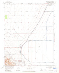
1963 Map of Kettleman City
USGS Topo · Published 1965About this map
Kettleman City sits at the base of the Kettleman Hills in this 1963 survey, overlooking the expansive agricultural flats of the Tulare Lake Bed. The town layout is clearly defined, showing its grid positioned near the Kettleman Hills Compressor Station and a network of critical infrastructure. An Aqueduct and multiple pipelines cut across the landscape, reflecting the intensive water management and industrial operations essential to this portion of Kings County.
Find a feature on this map
32 named features on this map. Tap any name to fly to it.
Don’t see what you’re looking for? This feature index may not catch every label — zoom into the map to look around manually.
Map Details
Editions of this 1963 Kettleman City Map
4 editions found
Other maps of this area

1912 · Coalinga
USGS Topo · 1:125,000

1914 · Lost Hills
USGS Topo · 1:125,000

1914 · Cholame
USGS Topo · 1:125,000

1915 · Cholame
USGS Topo · 1:125,000

1917 · Cholame
USGS Topo · 1:125,000

1929 · Stratford
USGS Topo · 1:31,680

1929 · Westhaven
USGS Topo · 1:31,680

1930 · Discovery Well
USGS Topo · 1:31,680

1930 · Kettleman Plain
USGS Topo · 1:31,680

1930 · Middle Dome
USGS Topo · 1:31,680