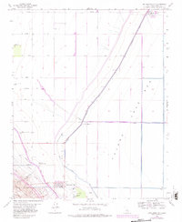
1963 Map of Kettleman City
USGS Topo · Published 1982About this map
Kettleman City serves as the focal point of this Central Valley landscape, situated at the intersection of a vast agricultural plain and the eastern slopes of the Kettleman Hills. The geography is defined by significant mid-century water engineering projects, most notably the California Aqueduct and the Blakeley Canal, which diverted water to transform the arid basin. To the east lies the dry expanse of the Tulare Lake Bed, a feature that once dominated this region but was reclaimed for large-scale industrial farming operations like West Lake Farms.
Find a feature on this map
26 named features on this map. Tap any name to fly to it.
Don’t see what you’re looking for? This feature index may not catch every label — zoom into the map to look around manually.
Map Details
Editions of this 1963 Kettleman City Map
4 editions found
Other maps of this area

1912 · Coalinga
USGS Topo · 1:125,000

1914 · Lost Hills
USGS Topo · 1:125,000

1914 · Cholame
USGS Topo · 1:125,000

1915 · Cholame
USGS Topo · 1:125,000

1917 · Cholame
USGS Topo · 1:125,000

1929 · Stratford
USGS Topo · 1:31,680

1929 · Westhaven
USGS Topo · 1:31,680

1930 · Discovery Well
USGS Topo · 1:31,680

1930 · Kettleman Plain
USGS Topo · 1:31,680

1930 · Middle Dome
USGS Topo · 1:31,680