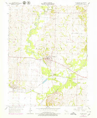
1956 Map of Keytesville
USGS Topo · Published 1979About this map
The Keytesville township and the neighboring Bowling Green district converge in this mid-century portrait of central Chariton County. The landscape is defined by the winding course of Mussel Creek and the Chariton River, which create a complex network of meanders and oxbows, such as Horseshoe Lake. The settlement pattern reflects a deeply rooted agricultural and institutional history, notably marked by the County Infirmary southeast of the main town.
Find a feature on this map
20 named features on this map. Tap any name to fly to it.
Don’t see what you’re looking for? This feature index may not catch every label — zoom into the map to look around manually.
Map Details
Editions of this 1956 Keytesville Map
2 editions found
Other maps of this area

1890 · Glasgow
USGS Topo · 1:125,000

1890 · Marshall
USGS Topo · 1:125,000

1892 · Marshall
USGS Topo · 1:125,000

1901 · Marshall
USGS Topo · 1:125,000

1949 · Indian Grove
USGS Topo · 1:24,000

1951 · Brunswick East
USGS Topo · 1:24,000
1951 · New Frankfort
USGS Topo · 1:24,000

1953 · Moberly
USGS Topo · 1:250,000

1953 · Bynumville
USGS Topo · 1:24,000
1953 · Mike
USGS Topo · 1:24,000