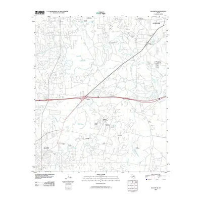
2010 Map of Kilgore NE
USGS Topo · Published 2010About this map
The Sabine River snakes across this East Texas landscape, defining the topography between the industrial growth of Longview and the northern reaches of Kilgore. In the early 21st century, the area shows a distinct transition from dense urban development in Greggton to the more rural, creek-divided lands near Danville and Fredonia. This survey documents a complex network of water management features, including Wickham Dam and Griffin Lake Dam, which support local reservoirs like Skipper Lake and Griffin Lake.
Find a feature on this map
41 named features on this map. Tap any name to fly to it.
Don’t see what you’re looking for? This feature index may not catch every label — zoom into the map to look around manually.
Map Details
Editions of this 2010 Kilgore NE Map
This is the sole edition of this map. No revisions or reprints were ever made.
Other maps of this area

1936 · Kilgore
USGS Topo · 1:48,000

1940 · Kilgore
USGS Topo · 1:62,500

1956 · Tyler
USGS Topo · 1:250,000

1958 · Tatum
USGS Topo · 1:62,500

1960 · White Oak
USGS Topo · 1:24,000

1960 · Gladewater
USGS Topo · 1:24,000

1962 · Longview Heights
USGS Topo · 1:24,000

1971 · Kilgore NE
USGS Topo · 1:24,000
1971 · Kilgore SW
USGS Topo · 1:24,000
1971 · Kilgore NW
USGS Topo · 1:24,000