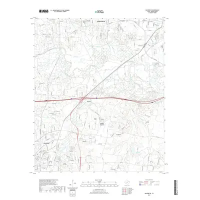
2019 Map of Kilgore NE
USGS Topo · Published 2019About this map
Longview and Kilgore anchor this 2019 survey of the East Texas oil fields, a landscape defined by the winding course of the Sabine River and its complex network of tributaries. The map details a transition from the urbanized edges of Greggton in the north to the industrial and residential pockets around Rolling Meadows and Danville. This modern topographic study reveals how contemporary infrastructure, such as the Kilgore Airport and several major loops, navigates the natural drainage of Rabbit Creek and Hawkins Cr. Genealogists and local historians can pinpoint several significant burial grounds, from the large Lakeview Memorial Gardens to smaller sites like Wilkerson Cem and Utzman Cem. The terrain is marked by numerous bayous and sloughs, including Wyms Bayou and Bullhole Slough, illustrating the persistent influence of the river's floodplain on regional development.
Find a feature on this map
102 named features on this map. Tap any name to fly to it.
Don’t see what you’re looking for? This feature index may not catch every label — zoom into the map to look around manually.
Map Details
Editions of this 2019 Kilgore NE Map
This is the sole edition of this map. No revisions or reprints were ever made.
Other maps of this area

1936 · Kilgore
USGS Topo · 1:48,000

1940 · Kilgore
USGS Topo · 1:62,500

1956 · Tyler
USGS Topo · 1:250,000

1958 · Tatum
USGS Topo · 1:62,500

1960 · White Oak
USGS Topo · 1:24,000

1960 · Gladewater
USGS Topo · 1:24,000

1962 · Longview Heights
USGS Topo · 1:24,000

1971 · Kilgore NE
USGS Topo · 1:24,000
1971 · Kilgore SW
USGS Topo · 1:24,000
1971 · Kilgore NW
USGS Topo · 1:24,000