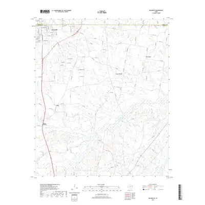
2019 Map of Kilgore SE
USGS Topo · Published 2019About this map
Pitner Junction and the small settlement of Pirtle occupy the western edge of this East Texas landscape, where the southern outskirts of Kilgore transition into a dense network of creek bottoms and small summits. The terrain is defined by its hydrology, with Tiawichi Cr and its tributaries like Cass Br feeding into the wetlands around Johnson Lake. To the north, Martin Lake sits along the Gregg and Rusk county line, a major landmark in a region characterized by timbered hills and rural homesteads.
Find a feature on this map
114 named features on this map. Tap any name to fly to it.
Don’t see what you’re looking for? This feature index may not catch every label — zoom into the map to look around manually.
Map Details
Editions of this 2019 Kilgore SE Map
This is the sole edition of this map. No revisions or reprints were ever made.
Other maps of this area

1935 · Henderson
USGS Topo · 1:48,000

1936 · Kilgore
USGS Topo · 1:48,000

1939 · Henderson
USGS Topo · 1:62,500

1940 · Kilgore
USGS Topo · 1:62,500

1956 · Tyler
USGS Topo · 1:250,000

1958 · Tatum
USGS Topo · 1:62,500

1960 · Minden
USGS Topo · 1:62,500

1971 · Kilgore NE
USGS Topo · 1:24,000
1971 · Kilgore SW
USGS Topo · 1:24,000
1971 · Kilgore NW
USGS Topo · 1:24,000