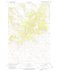
1974 Map of Killdeer Mountains
USGS Topo · Published 1977About this map
North Killdeer Mountain and the surrounding high plains of Dunn County dominate this mid-1970s survey. The landscape is defined by its geological and cultural landmarks, notably the Battle of Killdeer Mountain Historical Monument and the Killdeer Mountain State Game Management Area. The map reveals a drainage network including Spring Creek, Norred Creek, and Chase Cr, highlighting the water sources vital to this prairie environment. One interpretive detail is the presence of Medicine Hole, a significant natural feature on the eastern slopes, and numerous Gravel Pits that suggest local resource extraction. Ranching and land management are evident through the network of fence and field lines that segment the drainages of Oak Gulch and Gumbo Cr, providing a clear record of rural land use before modern development.
Find a feature on this map
17 named features on this map. Tap any name to fly to it.
Don’t see what you’re looking for? This feature index may not catch every label — zoom into the map to look around manually.
Map Details
Editions of this 1974 Killdeer Mountains Map
This is the sole edition of this map. No revisions or reprints were ever made.
Other maps of this area

1953 · Watford City
USGS Topo · 1:250,000

1957 · Watford City
USGS Topo · 1:250,000

1958 · Lone Butte SE
USGS Topo · 1:24,000

1958 · North Killdeer Mountain
USGS Topo · 1:24,000

1967 · Watford City
USGS Topo · 1:250,000

1970 · Lost Bridge
USGS Topo · 1:24,000

1974 · Killdeer
USGS Topo · 1:100,000

1974 · Petes Creek
USGS Topo · 1:24,000

1974 · Fayette
USGS Topo · 1:24,000
1974 · Killdeer
USGS Topo · 1:24,000