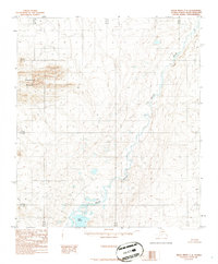
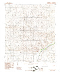
1986 Map of Killik River C-2
USGS Topo · Published 1986About this map
Pingaluligit Mountain dominates the western landscape of this North Slope region, standing as a prominent landmark amidst the intricate drainages of the Arctic wilderness. The Killik River meanders broadly through the central and eastern portions of the map, carving a wide valley floor marked by shifting channels and braided streams. Near the southern boundary, Lake Udrivik sits as a quiet focal point in the low-lying terrain. This 1986 provisional survey reflects the area's enduring character, focusing on the natural topography and hydrologic patterns rather than human infrastructure. The map reveals an environment defined by its water systems and the sharp rise of the mountains, illustrating the complex drainage patterns that feed into the Arctic watershed.
Find a feature on this map
9 named features on this map. Tap any name to fly to it.
Don’t see what you’re looking for? This feature index may not catch every label — zoom into the map to look around manually.
Map Details
Editions of this 1986 Killik River C-2 Map
This is the sole edition of this map. No revisions or reprints were ever made.
Other maps of this area

1951 · Killik River
USGS Topo · 1:250,000

1956 · Killik River
USGS Topo · 1:250,000
1984 · Killik River D-2
USGS Topo · 1:63,360
1986 · Killik River B-2
USGS Topo · 1:63,360
1986 · Killik River C-3
USGS Topo · 1:63,360
1986 · Killik River D-1
USGS Topo · 1:63,360
1986 · Killik River B-1
USGS Topo · 1:63,360
1986 · Killik River B-3
USGS Topo · 1:63,360
1986 · Killik River C-1
USGS Topo · 1:63,360
1986 · Killik River D-3
USGS Topo · 1:63,360