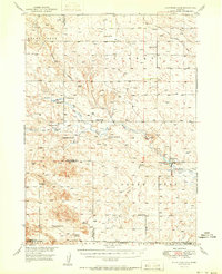
1951 Map of Kilpatrick Lake
USGS Topo · Published 1951About this map
Snake Creek and its complex tributaries, including the North Branch and South Branch, dominate this mid-century portrait of the Nebraska Panhandle. The landscape is defined by the cattle ranching economy of the late 1940s, marked by numerous family-named holdings such as Hood Ranch, Hall Ranch, and Orr Ranch. The network of country schools, from School No 31 in the north to School No 54 in the south, illustrates the rural settlement pattern before the consolidation of the late 20th century.
Find a feature on this map
28 named features on this map. Tap any name to fly to it.
Don’t see what you’re looking for? This feature index may not catch every label — zoom into the map to look around manually.
Map Details
Editions of this 1951 Kilpatrick Lake Map
2 editions found
Other maps of this area

1898 · Scotts Bluff
USGS Topo · 1:125,000

1898 · Camp Clarke
USGS Topo · 1:125,000

1899 · Whistle Creek
USGS Topo · 1:125,000

1946 · Nonpareil
USGS Topo · 1:24,000

1948 · Hemingford 4 SW
USGS Topo · 1:24,000

1948 · Hemingford 4 NW
USGS Topo · 1:24,000

1948 · Nonpareil
USGS Topo · 1:24,000

1951 · Marsland
USGS Topo · 1:62,500

1951 · Kilpatrick Lake
USGS Topo · 1:62,500

1954 · Scottsbluff
USGS Topo · 1:250,000
Featured Places
- Sheep Creek Precinct, NE
- Whistle Creek Precinct, NE
- Scotts Bluff County, NE
- Morrill County, NE
- Box Butte County, NE