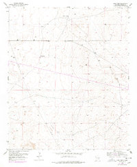
1951 Map of King Camp
USGS Topo · Published 1978About this map
King Camp and the Anchor D Ranch anchor this high-desert landscape in Chaves County, illustrating the sparse but vital ranching infrastructure of the mid-20th century. The topography is defined by subtle elevation changes across the Chaves County terrain, where water resources are marked simply by a Windmill to support livestock in an arid environment. A prominent Pipe Line cuts across the northern half of the quadrangle, signaling the industrial overlay of energy transport across the rural Southwest. This 1951 survey, photorevised in the mid-1970s, captures a transition in the ranching country of eastern New Mexico, where traditional land use met the expansion of utility corridors.
Find a feature on this map
8 named features on this map. Tap any name to fly to it.
Don’t see what you’re looking for? This feature index may not catch every label — zoom into the map to look around manually.
Map Details
Editions of this 1951 King Camp Map
Other maps of this area

1951 · Ninemile Well
USGS Topo · 1:24,000

1951 · King Camp
USGS Topo · 1:24,000

1951 · Diamond Mound
USGS Topo · 1:24,000

1952 · Connor Well
USGS Topo · 1:24,000

1952 · Bar C Bar Ranch
USGS Topo · 1:24,000

1953 · Basin Well
USGS Topo · 1:24,000

1954 · Carlsbad
USGS Topo · 1:250,000

1954 · Hobbs
USGS Topo · 1:250,000

1954 · Brownfield
USGS Topo · 1:250,000

1955 · Roswell
USGS Topo · 1:250,000