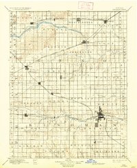
1894 Map of Kingman
USGS Topo · Published 1937About this map
The North Fork Ninnescah River and South Fork Ninnescah River dominate this late 19th-century landscape, carving paths through the grid-iron township system of Reno and Kingman counties. As surveyed by W.H. Herron and R.M. Towson in 1889, the region shows a dense network of emerging rail towns positioned along major arteries. The Kingman townsite serves as a central hub where the Wichita and Western Railroad meets the river, while the Chicago Kansas and Nebraska Railroad and Missouri Pacific Railroad cut diagonal paths across the section lines. Smaller settlements like Lerado, Penalosa, and Olcott dot the prairies between the larger centers of Arlington and Sylvia. This survey illustrates the precise geometric division of the Kansas plains, where township boundaries like Loda, Roscoe, and Ninnescah dictated the early organization of rural communities and homesteads.
Find a feature on this map
65 named features on this map. Tap any name to fly to it.
Don’t see what you’re looking for? This feature index may not catch every label — zoom into the map to look around manually.
Map Details
Editions of this 1894 Kingman Map
4 editions found

Other maps of this area

1889 · Anthony
USGS Topo · 1:125,000

1889 · Cheney
USGS Topo · 1:125,000

1889 · Caldwell
USGS Topo · 1:125,000

1891 · Great Bend
USGS Topo · 1:125,000

1891 · Medicine Lodge
USGS Topo · 1:125,000

1891 · Hutchinson
USGS Topo · 1:125,000

1891 · Cheney
USGS Topo · 1:125,000

1891 · Anthony
USGS Topo · 1:125,000

1892 · Kingman
USGS Topo · 1:125,000

1892 · Pratt
USGS Topo · 1:125,000