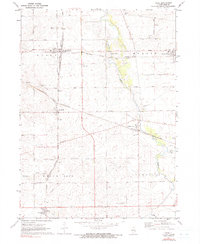
1971 Map of Kings
USGS Topo · Published 1991About this map
Davis Junction serves as a critical rail intersection in north-central Illinois, where the Chicago Milwaukee St Paul and Pacific meets lines formerly associated with the Burlington Northern. This 1970s landscape is defined by its agrarian order and the meandering course of Killbuck Creek, which flows past a series of early local landmarks including Killbuck Cem and a Gaging Station. The map illustrates a network of small settlements such as Monroe Center, Holcomb, and Lindenwood, each reflecting the mid-century stability of the Ogle County grain belt.
Find a feature on this map
40 named features on this map. Tap any name to fly to it.
Don’t see what you’re looking for? This feature index may not catch every label — zoom into the map to look around manually.
Map Details
Editions of this 1971 Kings Map
2 editions found
Other maps of this area

1917 · Kings
USGS Topo · 1:62,500

1918 · Kings
USGS Topo · 1:62,500

1918 · Kirkland
USGS Topo · 1:62,500

1934 · De Kalb
USGS Topo · 1:62,500

1937 · De Kalb
USGS Topo · 1:62,500

1949 · Camp Grant
USGS Topo · 1:24,000

1952 · Rochelle
USGS Topo · 1:62,500

1954 · Rockford
USGS Topo · 1:250,000

1955 · Rockford
USGS Topo · 1:250,000

1958 · Aurora
USGS Topo · 1:250,000