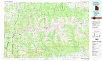
1982 Map of Kings Peak
USGS Topo · Published 1985About this map
Kings Peak stands as the centerpiece of this high-elevation mountain wilderness, where the borders of the Wasatch National Forest, Ashley National Forest, and Uinta National Forest converge. Compiled from surveys conducted between 1965 and 1972, this study reveals a landscape defined by dramatic glacial features and the headwaters of major drainages like the Lake Fork River, Uinta River, and Yellowstone River. To the north, the Bald Range transitions into the foothills of the Wyoming border, while the southern reaches descend toward the Uinta and Ouray Indian Reservation Boundary. The presence of Iron Mine Mountain and numerous high-altitude lakes such as Lake Atwood and Moon Lake reflects the resource-rich and recreational character of this remote backcountry during the late twentieth century.
Find a feature on this map
36 named features on this map. Tap any name to fly to it.
Don’t see what you’re looking for? This feature index may not catch every label — zoom into the map to look around manually.
Map Details
Editions of this 1982 Kings Peak Map
2 editions found
Other maps of this area

1885 · Salt Lake
USGS Topo · 1:250,000

1885 · Ashley
USGS Topo · 1:250,000

1885 · Uinta
USGS Topo · 1:250,000

1900 · Coalville
USGS Topo · 1:125,000

1901 · Hayden Peak
USGS Topo · 1:125,000

1903 · Hayden Peak
USGS Topo · 1:125,000

1903 · Coalville
USGS Topo · 1:125,000

1905 · Gilbert Peak
USGS Topo · 1:125,000

1906 · Gilbert Peak
USGS Topo · 1:125,000

1906 · Marsh Peak
USGS Topo · 1:125,000
Featured Places
- Moon Lake Resort, UT
- Christmas Meadow Summer Homes, UT
- Moon Lake Lodge, UT
- Sweetwater County, WY
- Summit County, UT