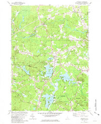
1981 Map of Kingston
USGS Topo · Published 1981About this map
Kingston and its surrounding villages in Rockingham County appear here as a landscape of interconnected ponds and historic corridors during the early 1980s. The town's colonial roots are evident at Ye Old Meeting House and the adjacent Ye Old Cem, while the central common is marked by the Kingston Plains Cem. The Powwow River system dictates the southern topography, linking Great Pond, Country Pond, and Greenwood Pond, which served as recreational and ecological anchors for the community.
Find a feature on this map
84 named features on this map. Tap any name to fly to it.
Don’t see what you’re looking for? This feature index may not catch every label — zoom into the map to look around manually.
Map Details
Editions of this 1981 Kingston Map
2 editions found
Other maps of this area

1888 · Newburyport
USGS Topo · 1:62,500

1888 · Haverhill
USGS Topo · 1:62,500

1890 · Haverhill
USGS Topo · 1:62,500

1890 · Newburyport
USGS Topo · 1:62,500

1893 · Dover
USGS Topo · 1:62,500

1893 · Haverhill
USGS Topo · 1:62,500

1894 · Newburyport
USGS Topo · 1:62,500

1916 · Dover
USGS Topo · 1:62,500

1917 · Mt. Pawtuckaway
USGS Topo · 1:62,500

1918 · Dover
USGS Topo · 1:62,500