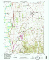
1992 Map of Kingston
USGS Topo · Published 1995About this map
Kingston serves as a primary hub in this Ross County landscape, situated near the intersection of the Kingston Adelphi Road and the Norfolk and Western rail line. The terrain transitions from the alluvial plains of the Scioto River to the prominent elevations of Sugarloaf and Bald Hill within Great Seal State Park. Of significant archaeological importance is the Hopewell Culture National Historical Park near Hopetown, preserving earthworks that reflect the region's deep indigenous history. The rural landscape is dotted with several houses of worship and resting places, including Crouse Chapel, Wesley Chapel, and the Miller Cem. Notable industrial activity is centered around the Sand and Gravel Pit near Centralia Sch, while recreational sites like Camp Davella and the Drive-in Theater highlight mid-century community life.
Find a feature on this map
46 named features on this map. Tap any name to fly to it.
Don’t see what you’re looking for? This feature index may not catch every label — zoom into the map to look around manually.
Map Details
Editions of this 1992 Kingston Map
This is the sole edition of this map. No revisions or reprints were ever made.
Other maps of this area

1906 · Chillicothe
USGS Topo · 1:62,500

1908 · Chillicothe
USGS Topo · 1:62,500

1911 · Era
USGS Topo · 1:62,500

1912 · Roxabell
USGS Topo · 1:62,500

1913 · Era
USGS Topo · 1:62,500

1914 · Roxabell
USGS Topo · 1:62,500

1914 · Circleville
USGS Topo · 1:62,500

1943 · Era
USGS Topo · 1:62,500

1943 · Circleville
USGS Topo · 1:62,500

1944 · Roxabell
USGS Topo · 1:62,500