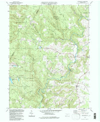
1994 Map of Kingwood
USGS Topo · Published 1997About this map
Laurel Hill and Laurel Ridge dominate this corner of the Somerset and Fayette county line, a landscape defined by steep drainages and large-scale public lands including Forbes State Forest and State Game Lands No 111. The topography is marked by numerous strip mines and gravel pits concentrated near Metzler and east of Kings Bridge, reflecting the region's industrial extraction history. In contrast to the heavy forest and mining tracts, small rural hubs like Kingwood provide evidence of local social foundations with the Kingwood Sch and Old Bethel Ch. A Covered Bridge on Laurel Hill creek and the remote Paterson Spring highlight the traditional Pennsylvania mountain character. The distribution of cemeteries and schools across Upper Turkeyfoot and Lower Turkeyfoot townships provides a clear record of family settlements nestled along the major water courses such as Middle Creek and Drake Run.
Find a feature on this map
56 named features on this map. Tap any name to fly to it.
Don’t see what you’re looking for? This feature index may not catch every label — zoom into the map to look around manually.
Map Details
Editions of this 1994 Kingwood Map
This is the sole edition of this map. No revisions or reprints were ever made.
Other maps of this area

1913 · Somerset
USGS Topo · 1:62,500

1915 · Somerset
USGS Topo · 1:62,500

1921 · Meyersdale
USGS Topo · 1:62,500

1922 · Confluence
USGS Topo · 1:62,500

1922 · Donegal
USGS Topo · 1:62,500

1931 · Confluence
USGS Topo · 1:62,500

1933 · Confluence
USGS Topo · 1:62,500

1935 · Donegal
USGS Topo · 1:62,500

1939 · Meyersdale
USGS Topo · 1:62,500

1944 · Somerset
USGS Topo · 1:62,500
Featured Places
- Springfield Township, PA
- Saltlick Township, PA
- Upper Turkeyfoot Township, PA
- Lower Turkeyfoot Township, PA
- Metzler, Upper Turkeyfoot Township