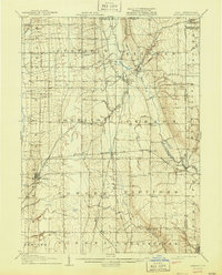
1907 Map of Kinsman
USGS Topo · Published 1944About this map
Pymatuning Creek and Mosquito Creek define the drainage of this northeastern Ohio landscape during the first decade of the twentieth century. The area is a dense network of early 1900s rail lines and small agricultural hubs, with the Erie RR and the Lake Shore and Michigan Southern threading through the townships of Kinsman and Vernon. These rail corridors were vital for the rural economy, supporting established stops like Farmdale PO Kinsman Sta and Nutwood Fowler Sta. Along the eastern margin, the Ohio Pennsylvania border cuts through the settlement of Orangeville, while the State Line Church stands as a landmark on the boundary line in Greene township. This survey preserves the exact locations of many family-named crossroads and post offices, from Gustavus to Hartford, before modern development altered these traditional Trumbull County town centers.
Find a feature on this map
61 named features on this map. Tap any name to fly to it.
Don’t see what you’re looking for? This feature index may not catch every label — zoom into the map to look around manually.
Map Details
Editions of this 1907 Kinsman Map
2 editions found
Other maps of this area

1905 · Andover
USGS Topo · 1:48,000

1905 · Bristolville
USGS Topo · 1:62,500

1905 · Jefferson
USGS Topo · 1:62,500

1905 · Neshannock
USGS Topo · 1:62,500

1906 · Linesville
USGS Topo · 1:62,500

1906 · Youngstown
USGS Topo · 1:62,500

1907 · Andover
USGS Topo · 1:62,500

1907 · Neshannock
USGS Topo · 1:62,500

1907 · Kinsman
USGS Topo · 1:62,500

1907 · Bristolville
USGS Topo · 1:62,500