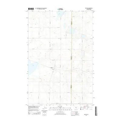
2014 Map of Kintyre
USGS Topo · Published 2014About this map
Kintyre serves as the primary settlement on this Central North Dakota prairie landscape, situated near the intersection of Cold Spring Ln and Cr-1529. The terrain is defined by the numerous glacial depressions and wetlands characteristic of the Missouri Coteau region, most notably Stink Lake in the north and Goose Lake to the west. This 2014 survey documents the precise boundary between Emmons Co and Logan Co, which runs vertically through the eastern portion of the map. The area's agricultural identity is reflected in the rigid grid of section-line roads, including 55th St SE through 63rd St SE, which facilitate access across this undulating plains environment.
Find a feature on this map
20 named features on this map. Tap any name to fly to it.
Don’t see what you’re looking for? This feature index may not catch every label — zoom into the map to look around manually.
Map Details
Editions of this 2014 Kintyre Map
This is the sole edition of this map. No revisions or reprints were ever made.
Other maps of this area

1953 · Jamestown
USGS Topo · 1:250,000

1954 · Bismarck
USGS Topo · 1:250,000

1956 · Jamestown
USGS Topo · 1:250,000

1958 · Bismarck
USGS Topo · 1:250,000

1975 · Linton NE
USGS Topo · 1:24,000

1975 · Braddock
USGS Topo · 1:24,000
1975 · Braddock NE
USGS Topo · 1:24,000

1975 · Kintyre
USGS Topo · 1:24,000

1979 · Bismarck
USGS Topo · 1:100,000

1979 · Kintyre NE
USGS Topo · 1:24,000