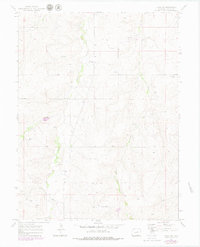
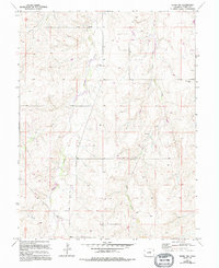
1970 Map of Kiowa NW
USGS Topo · Published 1979About this map
Kiowa Creek and Wolf Creek carve a northern path through this section of Elbert County, defining a landscape of drainages and intermittent water sources. The map provides a detailed look at rural land use during the 1970s, where the infrastructure of energy and agriculture is evident through a long Pipeline and scattered Oil Wells. Local history is anchored at the Ebenezer Cem, which sits near the junction of several drainage tributaries. Evidence of small-scale industrial activity appears in several Sandpits along the creek beds, while the presence of named Springs highlights the importance of water management in this high-plains environment. The survey also captures the fine network of fence lines, noted in purple during the late-seventies revision, revealing the precise boundaries of grazing and property divisions that shaped the region's ranching identity.
Find a feature on this map
12 named features on this map. Tap any name to fly to it.
Don’t see what you’re looking for? This feature index may not catch every label — zoom into the map to look around manually.
Map Details
Editions of this 1970 Kiowa NW Map
5 editions found
Other maps of this area

1890 · East Denver
USGS Topo · 1:125,000

1894 · Castle Rock
USGS Topo · 1:125,000

1913 · Castle Rock
USGS Topo · 1:125,000

1939 · Elizabeth
USGS Topo · 1:62,500

1945 · Elizabeth
USGS Topo · 1:62,500

1953 · Denver
USGS Topo · 1:250,000

1955 · Watkins SE
USGS Topo · 1:24,000

1957 · Denver
USGS Topo · 1:250,000

1958 · Denver
USGS Topo · 1:250,000

1960 · Denver
USGS Topo · 1:250,000