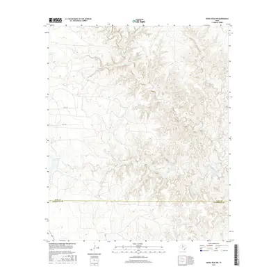
2016 Map of Kiowa Peak NW
USGS Topo · Published 2016About this map
Parramore Ranch Lake and the rugged drainage basins of the Texas Rolling Plains define this landscape on the border of King and Stonewall counties. The terrain is deeply carved by a network of seasonal watercourses, including the westward-flowing N Croton Cr and the complex system of Pen Branch and Pen Br in the southern half of the quadrangle. These drainages, along with Big Buffalo Cr, illustrate the erosional patterns characteristic of the Red River basin's headwaters. Human presence is sparse, marked primarily by ranch infrastructure like the Pen Br Tank and a few local routes such as Co RD 448 and Co RD 350. The map documents a sparsely populated ranching environment where the geography is dictated by the availability of water and the winding paths of creek beds.
Find a feature on this map
9 named features on this map. Tap any name to fly to it.
Don’t see what you’re looking for? This feature index may not catch every label — zoom into the map to look around manually.
Map Details
Editions of this 2016 Kiowa Peak NW Map
This is the sole edition of this map. No revisions or reprints were ever made.
Other maps of this area

1954 · Lubbock
USGS Topo · 1:250,000

1958 · Lovers Resort
USGS Topo · 1:24,000

1959 · Bob Creek
USGS Topo · 1:24,000

1962 · Kiowa Peak
USGS Topo · 1:24,000

1967 · Dark Canyon
USGS Topo · 1:24,000

1967 · Kiowa Peak NW
USGS Topo · 1:24,000

1967 · Kiowa Peak NE
USGS Topo · 1:24,000
1967 · Buzzard Peak
USGS Topo · 1:24,000

1967 · Kiowa Peak SW
USGS Topo · 1:24,000

1968 · Guthrie
USGS Topo · 1:24,000