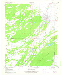
1967 Map of Kiowa
USGS Topo · Published 1978About this map
Kiowa and the small settlement of Reynolds anchor this 1967 survey of the Choctaw Nation's borderlands, where the Pittsburg Co Atoka Co line divides the landscape. The Missouri-Kansas-Texas railroad corridor serves as the central artery, flanked by industrial sites such as multiple Quarries and the municipal Waterworks. The map preserves the placement of essential community landmarks, including the High Sch in town and Harpers Valley Ch to the west, along with family and local burial grounds like Oak Hill Cem and Wards Cem.
Find a feature on this map
26 named features on this map. Tap any name to fly to it.
Don’t see what you’re looking for? This feature index may not catch every label — zoom into the map to look around manually.
Map Details
Editions of this 1967 Kiowa Map
2 editions found
Other maps of this area

1896 · Coalgate
USGS Topo · 1:125,000

1898 · McAlester
USGS Topo · 1:125,000

1899 · Coalgate
USGS Topo · 1:125,000

1900 · Coalgate
USGS Topo · 1:125,000

1909 · Mc Alester
USGS Topo · 1:125,000

1950 · Mcalester
USGS Topo · 1:250,000

1957 · Coalgate SE
USGS Topo · 1:24,000

1957 · Limestone Gap
USGS Topo · 1:24,000

1957 · Ardmore
USGS Topo · 1:250,000

1962 · McAlester
USGS Topo · 1:250,000