
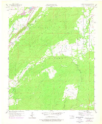
1957 Map of Limestone Gap
USGS Topo · Published 1958About this map
Limestone Ridge and Pine Mountain dominate this mid-century landscape where the Missouri Kansas Texas railroad cuts through the terrain. The map details a transition from the rugged upland forests of the Atoka State Game Refuge to the small rural communities of Chockie, Burg, and Wesley. Water sources like Martin Lake and the branching systems of McGee Creek and Chickasaw Creek illustrate the importance of drainage in these Choctaw Nation highlands. The placement of Limestone Gap and the nearby settlement of Gap highlight how early transit routes were dictated by natural breaks in the ridge, providing a clear view of the area's development before modern infrastructure altered the rural character of these Atoka County settlements.
Find a feature on this map
19 named features on this map. Tap any name to fly to it.
Don’t see what you’re looking for? This feature index may not catch every label — zoom into the map to look around manually.
Map Details
Editions of this 1957 Limestone Gap Map
2 editions found
Other maps of this area

1896 · Coalgate
USGS Topo · 1:125,000

1898 · McAlester
USGS Topo · 1:125,000

1899 · Coalgate
USGS Topo · 1:125,000

1899 · Atoka
USGS Topo · 1:125,000

1900 · Atoka
USGS Topo · 1:125,000

1900 · Coalgate
USGS Topo · 1:125,000

1901 · Antlers
USGS Topo · 1:125,000

1909 · Mc Alester
USGS Topo · 1:125,000

1912 · Antlers
USGS Topo · 1:125,000

1925 · Antlers
USGS Topo · 1:125,000