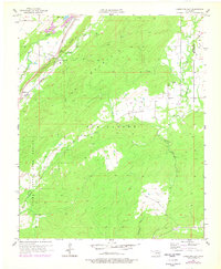
1957 Map of Limestone Gap
USGS Topo · Published 1978About this map
Limestone Ridge cuts through the northwest corner of this landscape, creating the namesake passage at Limestone Gap. This strategic corridor serves as the primary route for the Missouri Kansas Texas railroad line, which skirts the western edge of the mountainous interior. The topography is dominated by several large drainage systems, with McGee Creek and Nolleytubby Creek flowing through the central and eastern sections.
Find a feature on this map
20 named features on this map. Tap any name to fly to it.
Don’t see what you’re looking for? This feature index may not catch every label — zoom into the map to look around manually.
Map Details
Editions of this 1957 Limestone Gap Map
2 editions found

Other maps of this area

1896 · Coalgate
USGS Topo · 1:125,000

1898 · McAlester
USGS Topo · 1:125,000

1899 · Coalgate
USGS Topo · 1:125,000

1899 · Atoka
USGS Topo · 1:125,000

1900 · Atoka
USGS Topo · 1:125,000

1900 · Coalgate
USGS Topo · 1:125,000

1901 · Antlers
USGS Topo · 1:125,000

1909 · Mc Alester
USGS Topo · 1:125,000

1912 · Antlers
USGS Topo · 1:125,000

1925 · Antlers
USGS Topo · 1:125,000