
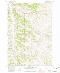
1967 Map of Kirby
USGS Topo · Published 1971About this map
Kirby serves as the central settlement in this portion of Big Horn County, situated along the banks of Rosebud Creek. The landscape is defined by the Northern Cheyenne Indian Reservation Boundary crossing the northern section, marking a distinct division in the local geography. Social and community life in the late 1960s is evidenced by the presence of St Francis Ch and the Log Sch located near Schoolhouse Coulee.
Find a feature on this map
21 named features on this map. Tap any name to fly to it.
Don’t see what you’re looking for? This feature index may not catch every label — zoom into the map to look around manually.
Map Details
Editions of this 1967 Kirby Map
2 editions found
Other maps of this area

1894 · Rosebud
USGS Topo · 1:125,000

1901 · Rosebud
USGS Topo · 1:125,000

1954 · Hardin
USGS Topo · 1:250,000

1957 · Hardin
USGS Topo · 1:250,000

1958 · Hardin
USGS Topo · 1:250,000

1958 · Bull Creek Lookout
USGS Topo · 1:24,000

1958 · Birdseye Spring
USGS Topo · 1:24,000

1967 · Tongue River Dam
USGS Topo · 1:24,000

1967 · Bar V Ranch NE
USGS Topo · 1:24,000
1967 · Taintor Desert
USGS Topo · 1:24,000