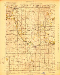
1918 Map of Kirkland
USGS Topo · Published 1918About this map
The South Branch Kishwaukee River and its northern counterpart dominate this northern Illinois landscape, carving through a region defined by established township boundaries and a dense network of early 20th-century rural infrastructure. This 1917 survey reveals a highly organized agricultural society, where almost every square mile is anchored by a named schoolhouse or church, including the Charter Oak School and Dutchtown School. These schools served as the social heart of small farm clusters, many of which were linked by a complex web of railroads.
Find a feature on this map
94 named features on this map. Tap any name to fly to it.
Don’t see what you’re looking for? This feature index may not catch every label — zoom into the map to look around manually.
Map Details
Editions of this 1918 Kirkland Map
4 editions found
Other maps of this area

1917 · Kings
USGS Topo · 1:62,500

1918 · Rockford
USGS Topo · 1:62,500

1918 · Belvidere
USGS Topo · 1:62,500

1918 · Kings
USGS Topo · 1:62,500

1918 · Kirkland
USGS Topo · 1:62,500

1932 · Harvard
USGS Topo · 1:48,000

1934 · De Kalb
USGS Topo · 1:62,500

1937 · De Kalb
USGS Topo · 1:62,500

1937 · Sycamore
USGS Topo · 1:62,500

1937 · Harvard
USGS Topo · 1:62,500