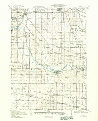
1918 Map of Kirkland
USGS Topo · Published 1941About this map
The Kishwaukee River and its South Branch serve as the primary geographical anchors for this agricultural corridor in north-central Illinois. In the early twentieth century, this landscape was defined by an exceptionally dense network of rural infrastructure, visible in the dozens of named country schoolhouses such as Flora Center School and Charter Oak School that served the farmsteads of Flora and Spring townships.
Find a feature on this map
90 named features on this map. Tap any name to fly to it.
Don’t see what you’re looking for? This feature index may not catch every label — zoom into the map to look around manually.
Map Details
Editions of this 1918 Kirkland Map
4 editions found
Other maps of this area

1917 · Kings
USGS Topo · 1:62,500

1918 · Rockford
USGS Topo · 1:62,500

1918 · Belvidere
USGS Topo · 1:62,500

1918 · Kings
USGS Topo · 1:62,500

1918 · Kirkland
USGS Topo · 1:62,500

1932 · Harvard
USGS Topo · 1:48,000

1934 · De Kalb
USGS Topo · 1:62,500

1937 · De Kalb
USGS Topo · 1:62,500

1937 · Sycamore
USGS Topo · 1:62,500

1937 · Harvard
USGS Topo · 1:62,500